Alice's Tour Pictures for Boston Topographical History Course

Landmaking
Tours
Central Waterfront
Bulfinch Triangle
West End
Beacon Hill Flat
Back Bay & South End
Fens, Fenway & Bay State Rd.
South Cove
South Bay & South End
South Boston
Dorchester
East Boston
Charlestown
I am the sole person responsible for the content of this photo gallery site. Please contact me if I have made any mistakes in citing a photo's location or detail.
Back Bay and South End
The failure of the Mill Dam led to the development of the Back Bay. Completed in 1821, the Mill Dam was intended to power a large number of tide mills but only a few were actually built. From the 1830s onward, train embankments running through the basins cut off tidal flows, and years of sewage dumping before and after the dam's creation necessitated filling in the tidal basins. The Commonwealth of Massachusetts, the Boston Water Power Company and the Boston & Roxbury Mill Corporation were the principal entities involved in this huge landmaking project.
The creation of the South End began just ahead of and then ran concurrently with the Back Bay project for a time. The areas of today's Bay Village, MassPike Towers and Castle Square were part of the Back Bay landmaking project, as were the laying of Tremont Street and Shawmut Avenue (formerly Suffolk Street) to provide additional access to the Neck Lands that had previously been accessible only on Washington Street since the establishment of Boston.
Streets in the Back Bay are Commonwealth Avenue; Arlington, Beacon, Boylston, Marlborough, Newbury Streets. Landmarks in the Back Bay include Trinity Church, the Boston Public Library, the First Baptist Church (aka the Church of the Holy Beanblowers), the Louis of Boston building (formerly the Natural History Museum). Major streets comprising the South End area are: Harrison, Shawmut and Warren Avenues; Appleton, Clarendon, East Berkeley, Herald, Tremont, Union Park Streets. Major landmarks and buildings in the South End area and its vicinity include the Cyclorama and the Villa Victoria housing community.
Arlington Street
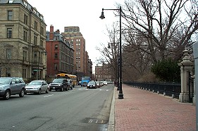
A View of Arlington
Street towards Beacon Street
From the 1830s through the 1850s, the Back Bay shore followed the line of
the Public Garden on the right. The Public Garden was created partly
on land made for and formerly occupied by ropewalks.
Boylston Street
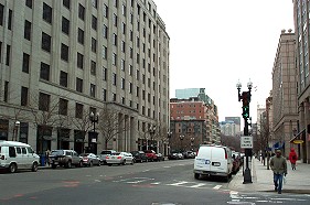
Boylston Street View
The constructions of the New England Life Building on the left and later 500
Boylston Street--facade on the right--found the remains of Native American
fish weirs under the fill.
Charles Street

Charles Street View
Prior to the creation of land that became the Public Garden, the left side
of Charles Street (facing northward) was the eastern shoreline of the Back
Bay. The Common stretches to the right of this camera shot, and the
visible building stands on Beacon Street.
Clarendon Street

Clarendon Street View
Clarendon Street runs behind Trinity Church on Copley Square. The
tower of the First Baptist Church can been seen just right of the
modern Boylston Street building in the center of picture.
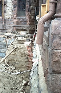
Excavation at Trinity
Church
Current renovations at Trinity Church includes work around its foundations.
This shot was taken near the Clarendon Street cloister and shows the
foundation down about 10 feet from street level.
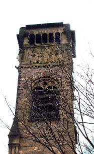
First Baptist Church
Tower
The First Baptist Church acquired the nickname "Church of the Holy
Beanblowers" because of the frieze of its tower, seen in this view.
Commonwealth Avenue
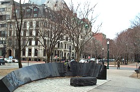
Vendome Memorial and
Hotel
The Vendome Hotel stands at Dartmouth St. and Commonwealth Avenue--the left
side of this picture. The memorial in the foreground commemorates nine
firefighters killed in the collapse of a part of that structure during a
1972 fire.
Copley Square
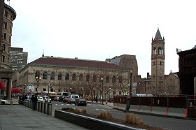
Copley Square from the
West
This view looks at Copley Square from the northeast corner of the Hancock
Tower. The camera position stands in the middle of the former
receiving basin.
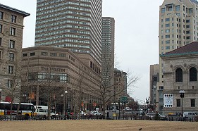
Copley Square Looking
Southwest
Today's Westin Hotel and Copley Place complex sit atop the railroad tracks
and Massachusetts Turnpike. The space was formerly an open green space with
a view of the tracks and highway below.
Dartmouth Street
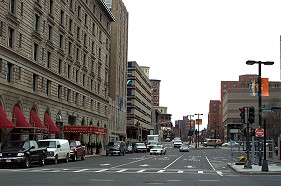
Dartmouth Street View
This view follows Dartmouth Street into the South End. Dartmouth Street is
one of only four streets in the Back Bay with a bridge over the railroad
tracks. The Copley Plaza Hotel on the left stands on the site of the
original MFA building.
© 2004 Alice Kane